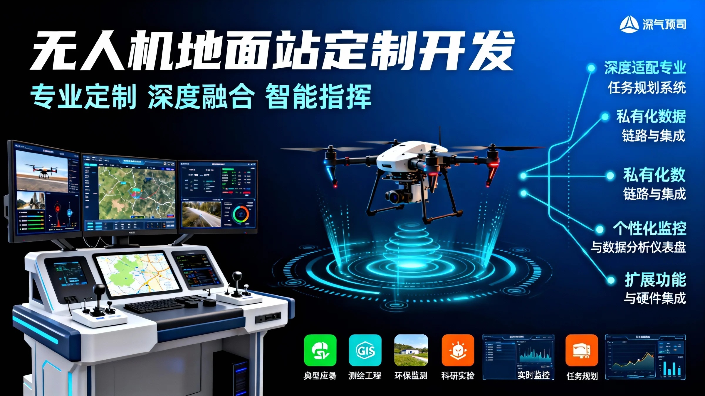
Standardized ground control station software often struggles to meet the deep needs of specialized industry users in terms of business process integration, professional functionality expansion, and proprietary protocol interfacing, leading to a disconnect between "software" and "operations." This product targets professional fields such as surveying, inspection, security, and scientific research, offering comprehensive custom development services from user interfaces to business logic. It aims to transform the ground control station from a basic "flight control terminal" into an "aerial intelligent command and data center" that seamlessly integrates with your workflows, precisely matches your professional needs, and smoothly interfaces with your data systems.
Core Customization Capabilities
1. Deeply Adapted Professional Mission Planning System
- Industry-Specific Mission Templates: Pre-configured and deeply optimized for scenarios such as power line inspection, pipeline patrol, and orthophoto mapping, standardizing expert pilot workflows into one-click mission planning.
- Advanced Waypoint Action Editing: Supports custom complex action commands for each waypoint, such as adjusting gimbal angles, toggling sensors, or hovering for photography, enabling fully automated and precise operations.
- Real-Time Terrain Following and Obstacle Avoidance: Integrates high-precision terrain data to automatically generate terrain-following flight paths in complex mountainous areas, with customizable obstacle avoidance radar sensitivity and response strategies.
2. Private Data Link and Integration
- Custom Data Communication Protocols: Develops specialized data parsing and transmission modules for uniquely modified UAVs or proprietary communication links (e.g., ad-hoc networks, satellite relays), ensuring stable and reliable command and data transmission.
- Localized Real-Time Data Stream Processing: Processes video feeds and telemetry data in real time with integrated edge computing capabilities, supporting real-time AI analysis (e.g., defect recognition, target tracking) and overlaying results back into the transmission stream.
- Seamless Integration with Enterprise Systems: Provides standard APIs and SDKs for effortless integration with existing enterprise asset management, work order, and geographic information platforms, enabling automatic task dispatching, data archiving, and one-click report generation.
3. Personalized Monitoring and Data Analysis Dashboard
- Single-Screen Aggregation of Critical Information: Customize the dashboard layout to aggregate all core information, including flight status, equipment health, mission progress, and real-time analysis results, based on your priorities.
- Augmented Reality (AR) Situational Overlay: Optional AR module that overlays real-time UAV positions, flight paths, and identified targets onto the user's field of view via tablets or AR glasses.
- Flexible and Configurable Data Reports: Users can customize report templates, with the system automatically generating standardized reports post-mission, including flight paths, operational coverage, and annotated issue points.
4. Extended Functionality and Hardware Integration
- Professional Payload Control and Coordination: Develops dedicated control panels and data visualization interfaces for specialized payloads such as multispectral cameras, LiDAR, and gas detectors.
- Multi-Station Coordination and Relay Control: Customizes task handover, data synchronization, and coordinated command logic between multiple ground control stations, supporting beyond-visual-line-of-sight (BVLOS) or long-endurance relay operations.
- Third-Party Peripheral Support: Integrates external equipment such as high-precision differential GNSS base stations and portable antennas to enhance overall system positioning accuracy and communication range.
Typical Customization Scenarios and Solutions
Scenario 1: "Integrated Field Workstation" for Surveying Engineering Companies
- Pain Points: Field personnel need to switch between multiple software tools, leading to cumbersome workflows, error-prone data, and difficult management.
- Custom Solution: Develops an all-in-one ground control station integrating mission planning, real-time flight control, quality inspection (real-time 2D orthophoto preview), and one-click data packaging and transmission. Post-mission data is automatically synchronized to the company’s intranet cloud storage, and preprocessing tasks are created automatically.
Scenario 2: "Mobile Emergency Monitoring Platform" for Environmental Protection Agencies
- Pain Points: During emergencies, rapid UAV deployment is needed for pollution source tracing and monitoring, with real-time analysis and reporting of gas and water quality data.
- Custom Solution: Develops a highly simplified "emergency mode" interface for one-click takeoff and automatic navigation to preset coordinates. Integrates real-time gas concentration heatmap rendering, automatic marking of超标 areas, and one-click generation of brief reports for submission to command centers.
Scenario 3: "Open UAV Experimental Platform" for Scientific Research Institutions
- Pain Points: Requires the ground control station to receive and parse custom sensor data while supporting flexible flight path algorithm validation.
- Custom Solution: Provides documentation and development examples for底层 data interfaces, enabling researchers to inject custom control algorithms or data visualization plugins. The ground control station offers robust logging and experimental data export functionalities.
Our Custom Development Service Process
- Collaborative Needs Analysis: Form a joint team with your business experts and pilots to thoroughly map out the entire operational workflow through workshops, defining功能 lists and acceptance criteria.
- Prototype Design and Agile Iteration: Quickly build interactive prototypes to demonstrate core workflows on actual hardware, iterating based on feedback to ensure the product aligns closely with user habits.
- Layered Testing and Validation: Conduct rigorous unit and integration testing, followed by multiple rounds of user acceptance testing by your pilot team in both simulated and real-world field environments.
- Deployment and Empowerment: Provide complete installation, deployment, operational training, technical documentation, and post-launch maintenance support to ensure your team can熟练 master and fully leverage the system’s capabilities.
- Continuous Evolution Support: Establish a long-term partnership to provide feature enhancements, performance optimizations, and version upgrades as your business evolves and technology advances.
Why Choose Us: Core Advantages
- Domain-Driven Design Thinking: We focus on understanding your business language and operational scenarios, ensuring the outcome is not a generic tool but an "industry-specific solution."
- Deep Technology Stack Expertise: Mature frameworks and extensive experience in real-time communication, GIS engines, 3D visualization, and data synchronization ensure system stability and efficiency.
- Transparent Project Management: Adopt agile development methodologies, with your全程 involvement and full visibility into project progress and quality control.
Custom Development of UAV Ground Control Station is a strategic investment to deeply embed aerial operational capabilities into your core business processes. What we deliver is not just software but a productivity multiplier and data value converter tailored to your team, unlocking the full potential of professional UAVs.